We tend to ignore it, perhaps out of shame, since we attack it all the time, despite needing it for everything. But we know of his power, of his way of claiming us, so it is time to learn about the climate characteristics and much more about him.

What is the weather like?
We will start by remembering that climate is a common word for everyone. Early in the morning, on the bus, when some of the passengers complain about the cold, we are also talking about the weather.
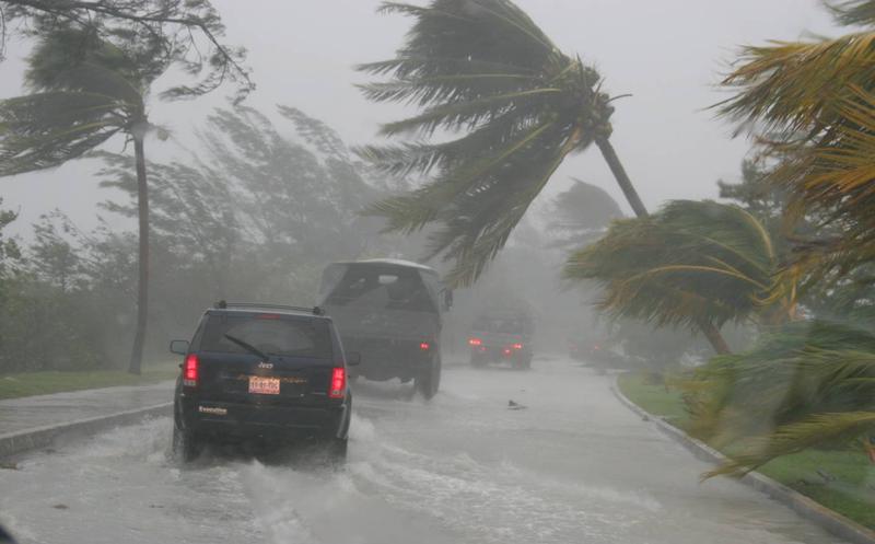
But we also do it when we hear on the news that a heat wave is coming, or maybe it is a storm that is on the way and an alert is declared.
In the store, we also use the word: climate, when we see that the costs of agricultural products have skyrocketed, they say because a strong summer damaged the crops.
Yes, it is always in our minds and mouths, we feel it on our skin and in our pockets, but what do we really know about the weather, beyond this morning's weather forecast?
So now is the time to learn more about this important topic. Let's start by knowing ¿what is the weather?
So let's start by specifying that the climate is a combination of components typical of a region. These components rain, humidity, temperature, pressure and wind.
The fact is that each region has its own ranges with respect to such components. But if any of these, or even two, can coincide in two different areas, the most feasible is that all the others are completely different.

The indices that qualify the climate of an area are obtained through the data weather 30 years prior and even more.
However, both in the imaginary line of the equator and in the polar caps, studies of this type can be carried out in periods shorter than those three decades, since they are regions that are much more stable than the rest of the planet, especially in the areas intertropical.
Factors that determine time
There are other factors that while allowing us a better weather definition, can also affect it. These are:
- Seasons
- Altitude
- Latitude
- Relief
- Continentality (distance to the sea)
- Ocean currents
Types of climate and zones
The most important climates, named generically, are three: hot, cold and temperate.
In this simple way we usually define the types of weather. But they still need to be related to the different areas of the planet. Let's see how that is.
We are talking about regions that are characterized by great cold, so countries from the extreme North, such as Canada and Russia, are located in them. While at the other extreme, the South, Chile and Argentina stand out.

But in temperate regions you can see countries like the US, Paraguay, Colombia or Australia, as well as a good part of Europe and Asia.
In the case of warm areas, the countries close to the imaginary fringe of the equator stand out, such as Ecuador itself and the north of Brazil, in South America, or the African Congo and Indonesia, in Asia.
However, we can classify climates in a more specific way. This will depend on the areas in which they are located in the world and the elements that determine them.
Perhaps the best known and used classification today is the one derived from the Köppen Climate Classification System, an invention of the Russian climatologist Wladimir Köppen.
In this mill, the different climate models are presented in sub-groups. In such a way that according to this criterion, the different climates of the world are classified as follows:

Group A: Warm or Tropical Climate
The climates of the hottest areas of the planet are located in this group. This category includes the regions distinguished by having an average temperature above 18°C/month. Here we find both jungles and tropical forests.
The sub-groups that make up this first group are differentiated by the volume of rainfall in said places, for which lowercase letters are used.
In such a way that regions with constant rainfall throughout the year are denoted by the letter "f". While those of constant rain, with the exception of some summer months and some with very heavy rainfall, are identified with the letter "m".
For areas with episodes of drought during the rainy season, the letter "w" is used. While the sites where the period of total lack of rainfall is located exclusively in the summer, and their classification is marked with an "s".
Equatorial or humid tropical climate (af)
The regions that make up this sub-group are those located very close to the imaginary fringe of the equator.
We are basically talking about the Amazon basin with certain areas of Brazil, as well as other regions in Central America, Equatorial Africa and some places in Southeast Asia.
These immense areas are distinguished by having a wide variety of lush green vegetation. This is precisely the result of the volume of rainfall, which keeps these regions with very high levels of Humidity.
In such a way that the flora in these orchards is very varied, since there we can find colossal trees over 30 meters high, as well as bushes and hundreds of different flowers.
While the animal life present in the sub-group is equally extremely diverse, both in large species and in tiny insects.
Tropical zone with monsoon climate (A.M)
Among the particularities that this subdivision reveals to us, it is worth noting that rainfall is scarce in certain months of the year, while in others the volume of water that precipitates becomes very profuse.
The generality is that in almost all the year these regions benefit from torrid showers, except for those exceptions mentioned that the differences of the previous category.
It rains so much that when you begin to see some Clouds, and the locals they know they should shelter from the storm.
This variety of climate is typical in certain areas of South and Central America, although it is also similar in the southern part of Florida, in the USA; on the African continent, in India and some regions of Southeast Asia.
Tropical savannah climate (aw and ace)
In this sub-group, one of the employees to determine the characteristics of the climate and thus be able to classify it, tropical climates can be found that have a season of the year without rainfall for a few months.
But instead the rainy months are often extremely intense.
In these cases, curiously, the dry season can occur indifferently in winter and in summer. Hence the initials "Aw", which locate the dry season during winter. While the initials "Ace" fix her in the summer.
The regions that are classified as Aw are basically located in certain regions of the American continent. They are also found in certain areas of the African Savannah, parts of northern Australia, the Indian subcontinent, and Southeast Asia.
While the characteristics of the climate defined by the As classification, we can observe them with special emphasis in some places in Central America and its neighboring Antillean islands, as well as in part of northern Australia.

Group B: Dry arid and semi-arid climate
Now we will see the characteristics of the climate that identify this new group. In the areas that host it, a very low average rainfall per year is recorded.
In this case, the sub-groups are differentiated with a second capital letter, which indicates the aridity of the areas in question. But in addition, in this classification a third letter is used, which is lowercase. This refers to the temperatures of each region.
But let's see how it's done:
If the climate is semi-arid, the letter "S" is used. This is somewhat similar to a steppe climate.
While the initial "W" is used to indicate the arid condition, which can be compared to a desert.
Now, the third and last letter that finishes fixing the characteristics of the climate in this sub-group, is used to indicate the temperatures of these regions.
In such a way that in the case of areas with average temperatures equal to or greater than 18°C/year, they are classified with the initial “h”.
In the event that these temperatures are below 18°C, these regions are identified with the letter “k”.

Semi-arid climate (BS)
The semi-arid climate is the one with an average rainfall per year close to 500 mm.
This type of climate can be observed in certain geographical areas of all continents, except the Antarctic.
In these conditions of little rain, the vegetation is also scarce; which is lower than in temperate and tropical regions. But the greenish vegetation is usually more scarce.
They are the characteristics of the climate typical of the steppes and semi-desert areas.
Now, when in a region with a semi-arid climate the average temperature/year is equal to or exceeds 18°C, then it is classified as «BSh-Warm Semi-arid».
But if the average temperature/year is below 18°C, it is classified as “BSk-Cold Semi-arid”.
Dry weather (BW)
Regions where the annual volume of rainfall is around 300 mm are classified as having arid climates.
They are characterized by very little Flora, where practically no greenish tones can be observed. Although it should not surprise us not to find any vegetation.
Deserts and certain semi-desert regions of the planet are located in this categorization.
In those climates with an average annual temperature equal to or greater than 18°C, the classification is made with the label “BWh-Arid Warm”.
While for geographical areas with an average/year of the thermometer, which are lower than the previous one, they will be distinguished as «BWk-Arid Cold».

Group C: Temperate Climate
Among the characteristics of the temperate climate that are used to establish this group, temperature stands out.
In this case, the temperature of the coldest month of the year must be less than 18°C, although greater than -3°C. While the average temperature of the hottest month must exceed 10°C.
To classify temperate climates, the second initial in the subgroups is lowercase, which accounts for the frequency of precipitation.
Let's see the details.
If the subgroup is defined with the initial “f”, this means that the rains are constant throughout the year. So we must understand that there is no specific dry period.
But if the subgroup shows a "w", it can be inferred that the season with the lowest level of rainfall is winter. So it coincides with the coldest period of the geographical region. However, this season does not have to be the rainiest.
But if the question is the other way around, that is, if the subgroup is identified with the letter “s”, this indicates that the period with less rain is summer, which is also the hottest season in the region indicated.
Although this does not mean that the rains have to occur mainly in the winter season.

also lowercase
In this categorization, the third initial, which is also labeled in lowercase, indicates the temperatures of these regions. Let's see how:
If the average temperature in the hottest month of the summer exceeds 22°C, it is considered to be a Sub-tropical zone and is identified with the lowercase initial “a”, as we have anticipated.
Now, if the hottest month of the summer does not exceed 22°C/average and the average temperatures of at least 4 months of the year exceed 10°C, we are in the presence of a temperate region. Its classification is marked with a lowercase 'b'.
But if the area has a sub-polar or sub-alpine climate, the average temperature of the hottest month of the year is less than 22°C. But if, in addition, the average temperature of at least four months of the year is below 10°C, then the climate is classified with the initial “c”.
Humid Temperate Climate (cf)
Here are included the regions where the influence of the oceanic zones makes the climate temperate. This same condition favors that the rains are distributed throughout the year. In such a way that there is no good summer seasonn demarcated.
Another characteristic of the climate in question is that rainfall never exceeds 2000 mm/year.
It is a climatic group divided into three sub-categories. Let's see.

- Cfa-humid subtropical climate
In what is also known as the Pampean Climate, the average temperature of the hottest month exceeds 22°C.
Certain regions of the eastern United States, southern Brazil and Paraguay are located here, as well as Uruguay, central Argentina, part of South Africa, Japan, Australia and some places on the old continent.
- Cfb-Temperate oceanic climate
In areas with this type of climate, the average temperature of the hottest month does not exceed 22°C. However, they are above the average 10°C in at least four months of the year.
This is named oceanic or Atlantic climate. It can be seen north of the western part of the old continent, as well as in the Iberian region. In addition to southern Chile, New Zealand areas, Tasmania and in some regions of South America.
Cfc-Oceanic subpolar climate
In this geographical area the climate is colder. Its average temperature only exceeds 10°C in less than four months of the year.
These are ostensibly cold oceanic climates, close to the polar ice caps. For this reason, temperatures generally exceed -3°C, while precipitation occurs constantly and profusely.
This form of climate is also affected by the heights of the geographical areas.
It is a climate that can be found in regions such as southern Argentina and Chile, or in Scotland and other parts of the United Kingdom, as well as some areas of Tasmania, Norway and the Atlantic islands, especially Iceland and the Faroe Islands.

Mild Climate with Dry Winter (ww)
The regions where this climate occurs are generally found between the latitudes that establish tropical and subtropical temperatures, which in turn have elevations.
In these places, in winter the rains are ostensibly lower compared to the other seasons of the year. But this does not mean that the heat wave is rainy, since it does not fall more than 2000 mm/year.
This group is also subdivided into three subcategories. Let's see which ones.
- Cwa-Subtropical climate with dry winter
In this sub-group, the average temperature of the hottest month exceeds 22°C, while the winter season generally has very low volumes of precipitation.
In these cases we can find a climatic transformation tending towards the tropical. For this reason, sometimes the summer rains tend to be strong and abundant.
It is a typical climate, especially in some inland regions of China, Paraguay, Argentina and South Africa.
- Cwb-Temperate mountain climate with dry winter
Here the average temperature of the hottest month does not exceed 22°C, but it does exceed an average temperature of 10°C during at least four months of the year.
It is a basically common climate in cities that are located at high altitudes in temperate zones, as is the case in part of the Andes, northern South America, Central America and in certain cities in Africa.

Cwc-Subalpine climate with dry winter
In this climate, average temperatures above 10°C are recorded in less than four months of the year. It is typical of very high regions, so it is rare.
It occurs primarily in certain cities of Bolivia, Peru and Ecuador.
Mediterranean climate (cs)
In this categorization of the climate, the rains are ostensibly lower in the summer than in the other seasons of the year. But this does not mean that most of the rains occur basically in winter.
As in the two previous groups, this one is also subdivided into three, according to temperatures.
Csa-Typical Mediterranean climate
During the hottest month of the year, the average temperature exceeds 22°C. It is a climate characterized by warm temperatures and seasonal rains.
It is specific especially to the Mediterranean area, but it can also be found in some Chilean, southern US, European and Australian regions.
Csb-Mediterranean oceanic climate
The geographical regions that have this classification do not exceed 22°C on average in the hottest month of the year, but their average falls below 10°C in at least four months of the year.
This climate is characteristic of some areas of central Chile, as well as southwestern Argentina and the west coast of the US. It can also be seen in southeastern Canada, certain parts of Portugal, and in South Africa.
Csc-Mediterranean subalpine climate with dry summer
It is an uncommon climate. It is largely determined by altitude.
The average temperature in this type of climate exceeds 10°C in less than four months of the year.
Group D: Continental Climate
This climate categorization is characterized by very cold winters. An average temperature of the hottest month above 10°C stands out. While the average temperature of the coldest month of the year is below -3°C.
For this categorization, the sub-classifications are identified with a second letter that is written in lowercase. This refers to the rainfall regime. But let's see how it's done:
In this case, when the rains occur regularly throughout the year, without a dry period, it is identified with the letter "f".
But when the rainy cycle coincides with the winter cycle, it is identified with the letter “w”.
Now, if the thing is that the rainfall cycle occurs in the summer season, it is marked with the letter "s".
For this classification, the third equally initial is also drawn in lowercase and refers to the behavior of temperatures.
For this purpose, it is identified with the letter "a" if it is a very hot summer. This is because on average 22°C are exceeded in the hottest month of the year. Here the average mark of the thermostat exceeds 10°C four or more months of the year.
Now we must bear in mind that if the letter "b" is labeled, it is because summer is benevolent, since it does not reach the average of 22°C during the hottest month. But on average 10°C are exceeded in at least 4 months of the year.

very cold weather
While the letter "c" identifies the regions where the summer does not reach 22 ° C on average, in the hottest month.
But also that the average of 10°C is not exceeded in more than 4 months of the year and that the thermometer during the coldest month of the year does not register a temperature higher than -38°C.
When the letter "d" is used in the classification, it is because the thermometer does not reach an average of 22°C during the hottest month. But equally, average temperatures above 10°C occur in less than four months of the year.
Another condition of this classification is that the average temperature of the coldest month does not exceed -38°C.
Continental climate with constant rainfall (df)
In this categorization of continental climate, the rains are distributed throughout the year. So there is no dry season.
But now let's see the sub-divisions:

- Dfa-Temperate continental climate
In this subdivision, the average mark of the thermostat in the hottest month exceeds 22°C. It is a climate typical of some regions of Russia and Ukraine, although we can also find it in regions of Canada and the USA.
- Dfb-Hemiboreal climate without dry season
We start by explaining that the term hemiboreal describes something that falls between the temperate and subarctic zones.
In this type of climate, the temperature does not touch the average of 22°C in the hottest month, although on average it does exceed 10°C in at least 4 months of the year.
This climatic form can be found mainly in the northern region of the old continent and some of Canada and the USA.
- Dfc-Subpolar climate without dry season
Here the average temperatures above 10°C occur in less than three months a year. While the coldest month is located on the range of -38 ° C.
It is a characteristic climate of areas such as Siberia, Scandinavia and Alaska. Although it is also recorded in places of high elevation, such as the Himalayas.
- Dfd-Extreme climate without dry season
For this sub-categorization, the average temperature of 10°C is recorded in less than three months a year. But when it comes to the coldest month, it can exceed -38°C.
Such a climate can be found north of Alaska and in its neighboring northern part of Siberia.

Continental climate with dry winter (dw)
Here there is a significant decrease in the volume of water that falls in winter time. It can occur mainly in some regions of Russia, Korea, China, Mongolia, and in certain areas of the US and Canada.
- Dwa-Temperate continental climate
Here the average mercury mark in the hottest month exceeds 22°C. This feature can be found mainly in certain places in China and North Korea.
- Dwb-Hemiboreal Climate
In this case, the average temperature of the hottest month never exceeds 22°C, although it does exceed the average of 10°C for more than 4 months a year.
- Dwc-Subpolar climate with dry winter
Here the months that are recorded with an average temperature greater than 10 ° C, are less than four a year. While in the coldest month, they exceed -38°C.
Such conditions are typical of certain places in Russia, Mongolia and Alaska.
- Dwd-Subpolar climate
This subdivision is characterized by having less than three months of the year where the average temperature exceeds 10°C. Likewise, the coldest month can exceed -38°C.

Continental climate with Mediterranean influence (ds)
During the summer period, the rains decrease ostensibly, which is why it is considered as the dry season.
This climatic category generally occurs in the vicinity of the highest regions of the Mediterranean.
But it is not a very common climate. It is mainly observed in the Caucasus region and the Sierra Nevada, in addition to certain sites in Iran and Turkey.
But this climatic category also has its sub-divisions; Let's see what they are and how their nomenclatures are expressed.
- Dsa-Mediterranean continental climate
In this sub-group of climatic categorization, the mean temperature of the hottest month exceeds 22°C.
- Dsb-Mediterranean hemiboreal climate
Although in this region the average temperature of the hottest month does not exceed 22°C, it does exceed the average of 10°C in a minimum of 4 months of the year.
- Dsc-Subpolar climate with dry and short summer
In this sub-division, there are less than four months of the year that have an average temperature that exceeds 10°C. While the temperature of the coldest month is around -38°C.

- Dsd-Strong subpolar climate with dry summer
This represents the last sub-division of this climate category. Here the average temperature of 10°C is not exceeded in more than four months of the year.
While in the coldest month the temperature can even exceed -38°C.
Group E: Polar Climate
This climatic categorization is characterized by the fact that the average temperature of the hottest month of the year does not exceed 10°C.
Another characteristic of its own is that the flora is similar to what we usually find in icy desert areas.
In this categorization, capital letters are used for their nomenclature. Here the "T" determines the tundra climate, while the "TH" or just "H", refers to a tundra climate at high mountain altitudes.
The other case is the "F", which is used to determine an absolutely freezing climate.
tundra climate (AND)
For this type of climate, the average temperature of the hottest month of the year is between 0°C and 10°C.
It is also characterized by predominantly herbaceous vegetation during the months when temperatures exceed 0°C.
In such a way that this climatic sub-division can be found basically on the coast of the Arctic Ocean and the Antarctic Peninsula.
However, it also occurs in Greenland, some places in Russia, in the Malvinas Islands of Argentina and in the Magallanes area in Chile.

Alpine climate (ETH/H)
This climatic form is the equivalent of the tundra, but it occurs in conditions of lower temperatures. This is because it is located in areas of very high mountain heights.
It is a characteristic climate of Peru, specifically in the communities of Puno and El Alto, in addition to the city of La Rinconada, the highest in the world, located at an altitude of more than 5100 meters above sea level.
Frigid weather (FE)
This can also be described as a climate of extreme cold, where the average temperature of the hottest month is 0°C.
But one of its important features is that these sites do not have vegetation. This is because in these cases the ground is ice and snow, almost entirely.
These conditions are typical of the interior of Greenland, but are also found in almost all of Antarctica.
As a curious fact, it is precisely in the frigid Antarctica, specifically at the Russian research station based in Vostok, where the lowest temperature measured in the world was recorded. This reached a whopping -89,2°C.
With this last qualification we conclude this extensive segment, but very necessary to know what are the types of weather.
But there is still more, because we do not propose to explain all about the weather. So it is best to continue forward, where more information awaits us.
Climate and weather
Something very common is that the climate is confused with the weather of a particular site.
It is necessary to clarify that this is a colossal mistake, although extremely frequent. This is because colloquially both terms are used interchangeably for the same thing, although technically they are very different.
But not only are these two words not synonymous, but what defines each one is calculated or measured in different ways.
In such a way that we will begin by explaining to you that when we talk about the weather, also known as atmospheric weather.
We refer to the condition that the atmosphere presents in a certain place, during a short period of time, which can be days or even hours.
While when we talk about climate we are referring to the atmospheric model of a particular site or region.
But unlike the previous case, here a much longer cycle is taken as a basis, which generally exceeds 30 years of study. It is a time when very precise information is collected from the study areas.
Although they agree that both the climate and the weather are part of what is known as well-defined research.
At this point it is necessary to explain that meteorology is a division of atmospheric physics intended for the investigation of weather and atmospheric activity that cause temperatures.
For its part, climatology is a branch of geography, which is dedicated to climate research in different areas of the planet. It is also responsible for the variation of the climate through the chronological period.
a vast field
But in turn, Meteorology is segmented into several branches that are dedicated to the study of somewhat more complex areas.
So we can see her dealing with everything from the weather forecast to atmospheric movements, their conditions and properties.
But it covers much more, such as the consequences of the sun's rays on the planet's atmosphere and research on the air, in addition to atmospheric pressure and temperature.
However, the study of the stability and conformation of air volumes and clouds must be added to their responsibilities. As well as rains, cyclones and monsoons, among other broader research areas.
But if the Climatology uses some standards and records equally used for the different investigations in Meteorology, the purposes or goals of study are different.
This is because the aim is not to achieve instant results, but to study the different climatic characteristics of the different regions of the planet in the long term.
In such a way that the two fields act together as a link.
This is the case of Meteorology, when it functions as a complementary science to Climatology.
This is necessary because the long-term computations of both climatic and atmospheric models require the records collected at meteorological stations around the world.
In this way you can set the climate of a specific area. But it also manages to forecast the weather and establish the movement of the clouds with the passage of the day.
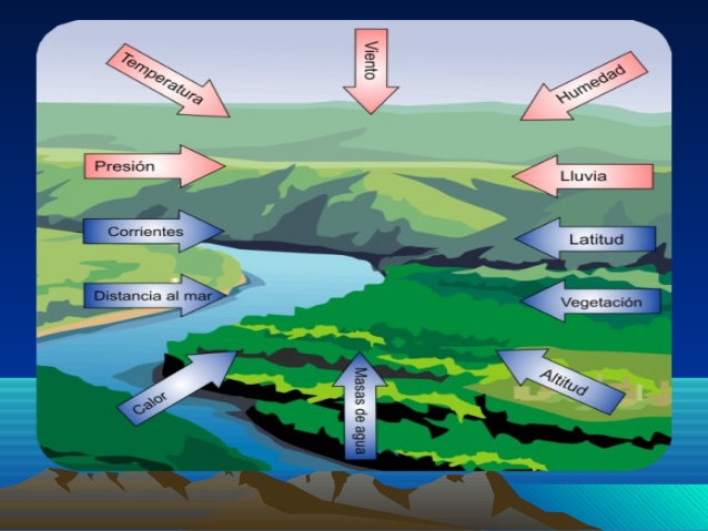
Factors that determine each climate
To establish the climate of a particular area, there are some factors to consider, especially when calculating the climate of the area.
These are six factors that we detail below:
- Latitude
- Altitude
- Topography Orientation
- Distance to the sea
- Ocean currents
- planetary winds
Latitude
The first of these factors: latitude, is understood as the oblique distance between the imaginary line of the equator -which separates the planet into two hemispheres- and a specific place on the globe.
To set a specific site in any of the indicated hemispheres, latitude is used, which is circumscribed between the equator strip at 0°, up to the poles. In such a way that the North Pole is fixed at 90°N and the South Pole at 90°S.
The Latitude of a specific location is stated in degrees (°). While the fractions of these degrees are expressed in minutes (') and seconds ('').
But we must explain that depending on the part of the world where the site to be marked is located, the latitude can be indicated in two different ways.
In such a way that for those located in the northern part of the world, for example at a latitude of 15°, the corresponding nomenclature would be: 15°N, or simply +10°.
On the other hand, if the site to be marked is in the opposite hemisphere to the previous one, that is, the south, assuming a latitude of 15°, then the nomenclature would be 15°S or simply -15°.
Sexagesimal System
This form of nomenclature obeys the Sexagesimal System. The example of a complete sequence in this nomenclature could be, for a site in the northern part of the world: +60° 45' 52''.
In this System, one degree is equal to 111,12 km, while one minute is equal to 1852 m, or what is the same as one nautical mile. Finally, one second is the equivalent of 30,86 m.
But when we talk about the climate, the latitude determines the degree of penetration of the sun's rays, as well as the time that a day and a night last according to the solar incidence.
At this point it is important to mention that the differentiations of the sunlight that bathes the world, is given thanks to the movements of the planet. This is what establishes both the differentiations of the days and the seasons.
In this way, the changes in latitude along with the angle formed by the earth's axis of rotation, fixes the temperature variation between the different seasons of the year in the multiple regions of the planet.
Although it also exerts its influence in establishing the location where the epicenters of the activity caused by the winds occur, as well as the cyclonic and anti-cyclonic zones.

Altitude
Altitude can be defined as the distance, measured vertically, that exists somewhere on earth in relation to sea level.
The nomenclature that originates from this is usually expressed in an abbreviated way as follows: (msn) This means meters above sea level.
Altitude is an element that strongly affects the climate. This is because the higher the altitude, the lower the temperature. It is an inversely proportional relationship.
But this in turn generates a classification of thermal floors, which are guided by factors such as flora, heat and cold, as well as topographical layout.
Here we will refer to the four most accepted thermal floors. This is how the temperatures of the regions are set by the criteria that we will see next:
- P1-Macrothermal: It is established less than a thousand meters high. There the temperature differs between 27° at sea level and 20° at the highest point.
- P2-Mesothermal: This floor is set between one thousand and one thousand three hundred meters high. This is where a variation between 10°C and 20°C is observed. It is called temperate mountain climate.
- P3-Microthermal: It is a strip of altitude between three thousand and four thousand seven hundred meters. There the temperature oscillates in a range that goes from 0°C to 10°C. This characteristic constitutes a cold climate.
- P4-Cold: Beyond an elevation of 0 feet, the average temperature is below XNUMX°C. This forms a landscape with perennial snow, that is, snow that never melts due to solar incidence.

Topography Orientation
The orientation of the topography represents the arrangement of the mountains and mountain ranges. Such orientation is determined depending on the incidence of solar rays.
In this way you can find mountainous slopes called solana, in addition to others known as Umbria.
For these purposes, it should be specified that Solana is the name given to the foothills or slopes of the mountainous regions, which generally collect more solar radiation.
In such a way that in these areas greater luminosity is observed during the day. In addition to less shade in relation to the slopes called Umbría, where on some occasions the shade remains for weeks.
Depending on the solar incidence, the slopes of Solana and Umbria will show differences in terms of temperatures. Which makes the slopes of Solana more populated, as well as being more efficient for agricultural activities.
Now, in the case of the slopes and slopes of Solana located in the northern hemisphere, they are pointing south, in the opposite direction. While those located in the southern hemisphere, are pointing north, also in the opposite direction.
But the slopes and slopes of Umbria, are those that in the northern part of the world point north, while in the opposite hemisphere they point south.
In addition to these two cases, there is a very particular one. It turns out that when the slopes that are on the imaginary strip of the terrestrial equator, whether they point south or north, they have six months of Solana and another six of Umbria.
While the mountains that are oriented towards the west, the slopes of Solana and Umbria can be found at the same time.

Distance to the sea
The distance to the sea, also known as Continentality, represents one of the basic elements with the greatest influence on the climate of a given geographic region.
In such a way that a long distance with respect to the marine masses, makes it difficult for the humid wind to reach the central areas of the continents.
With this comes a decrease in rainfall in those regions. The fact is that when the source of water is distant from where the wind transports the humidity, necessary for the creation of the clouds that will eventually give rise to the much-needed worries, what arrives is drought.
For this reason, the zones in question show a fairly wide thermal width. There a great discrepancy of temperatures enters perfectly, in regards to day and night.
This is because in just a few hours, temperatures can go from below zero to even more than 40°C. This is very common in desert areas.
But such an event also causes summers to be more torrid, with extremely cold winters, especially at night.
This is the product of water currents, which also make it easier to maintain lower temperatures in summer and warmer ones in winter. It is something that occurs thanks to the fact that the waters absorb heat directly from the sun's rays.
To be more precise about this important task, we must point out that just as water takes an impressive time to heat up, it also takes a long time to cool down.
This is in relation to the continental zones, in such a way that water represents one of the most important elements in the moderation of climate and temperatures.

Ocean currents
These currents play a very important role in terms of temperature and climate in a specific region.
For this we must understand that just as the ocean acts as a climate regulator, marine and sub-oceanic currents also intervene in continental climates.
In this sense, running showers have the task of transferring water masses, with which they also transfer thermal energy, which is the same as heat.
In this way, the water currents of a particular region can intervene in the temperature of the waters of more distant areas. Such is the case of the warm currents of the Gulf of Mexico.
These are well-known currents for their influence on ocean waters on the other side of the world, especially in Portuguese and Spanish territory.
In these two regions of the old world, the waters are usually warmer than in different countries or areas at lower latitudes. An example would be that of the Canary Islands, or Mauritania in Africa, where the currents carry cold water despite the fact that these countries are closer to the equatorial belt.
Such an event confirms that the temperature influence of these currents may not be directly related to latitude.
Intertropical zone
This also exerts an influence on the climate of a particular region. Such is the case of the region demarcated by the imaginary strip known as the Intertropical Zone, more specifically on the western coasts of both America and Africa, where an arid climate predominates.
It is a phenomenon produced by the rise from the seabed to the surface of cold currents.
This invariable ascent of fresh waters generates a high atmospheric pressure. However, the humidity of these streams is very low, so rainfall is extremely low or even non-existent throughout the year.
As an example of this, we can cite the Chilean Atacama desert, one of the driest in the world, which sits very close to the Pacific Ocean.
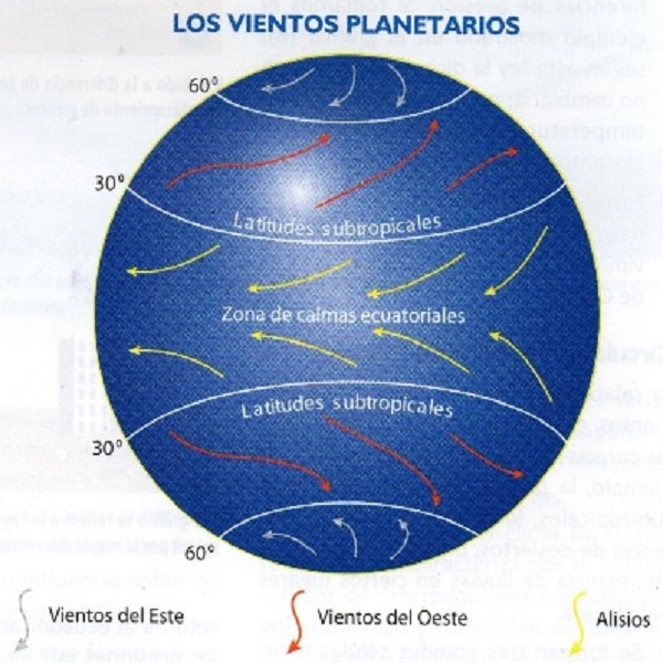
planetary winds
This name identifies the movements and waves of air masses generated by the action of the planet's rotation. They are in charge of transferring colossal amounts of thermal energy to the meridians of each part of the world.
By keeping these currents constantly moving, they facilitate the transfer of heat in large air masses to large land areas.
To these we give the name of trade winds, when we refer to the intertropical zones. While for temperate regions, the name we give is easterly winds.
Another planetary wind modality is the well-known Monsoon, specific to Asian regions and those close to the Indian Ocean. It is a wind caused by seasonal temperature variations between the air masses of the continents and the sea.
During the course of the summer in this region, a condition of continental low pressure is generated.
Such an effect attracts bodies of torrid and humid winds from the Indian Ocean, thus generating heavy rainfall of mountainous origin. This is due to the proximity of the Himalayas, which acts as a barrier to rising winds in the region.
But in winter time this event occurs in the opposite way. This is because the continental masses arrive devoid of moisture, so these winds with their dry air move to the Indian Ocean.
Similar effects also occur in certain regions of the US, although their effects are not as pronounced as in the area of the Asian continent described above.

Climate changes and pollution
Climate change is surely one of the greatest challenges that humanity has been facing in recent decades.
This global problem represents a threat to the environment and to the very subsistence of human beings. In this way, it is a topic that is constantly gaining relevance. It is also considered a key point for debate in the media and social networks.
But to advance the point, we must remember that throughout the planet's existence, this global home has been affected by cycles of natural change. Among these periods we can point out the glaciations, although we must add seismic cycles and intense solar radiation.
However, climate change does not occur exclusively due to the natural action of the planet, but rather receives the strong influence of the hand of man. This occurs with poor management and even with the excessive exploitation of land resources, especially fossil fuels, which are extremely polluting.
We can cite some of the most damaging activities:
- Indiscriminate felling of forests.
- Misuse of drinking water.
- Overexploitation of soils for industrial purposes.
- Release of toxic and polluting gases into the atmosphere and burning of fossil fuels.
- Accumulation of toxic waste in the sea.
The good news
The sum of these practices accelerates global warming, which as we already know is one of the most serious threats facing humanity.
Such evils merit prompt action on the part of the competent authorities and political groups around the world. The idea is to set regulations for the proper use of the planet's resources, as well as for the protection of natural spaces.
But not everything is bad. A light of hope is lit with the progress made day by day, in the sense of promoting the proper use of natural resources. In addition, at the same time, research on green or renewable energies is strongly encouraged, in order to replace the current system.
The five best weather forecast websites
To end our post, we will dedicate the last segment to the five most viewed portals dedicated to predicting the weather.
Since if you have reached this point with us, it is because you are undoubtedly passionate about the subject and in this way you must also be one of the people who like to go out prepared for the weather that you are going to get out there in the course of the day.
So here we recommend the five best weather websites, just in case you don't trust the Weather Girl on the morning news.
The Weather Channel
The Weather Channel website, Weather.com, is one of the simplest and most complete when it comes to checking the weather, not only in your specific region, but also in the entire planet.
AccuWeather
In the case of smartphones, remember that some of these already come with the accuweather.com weather forecast system preset.
But we can also enter from its website to enjoy a simple and pleasant page with advantageous tools that help us know the weather in different parts of the world.
Here we can even know the forecasts several months in advance.
One of its most attractive advantages is that it shows satellite images with atmospheric movement.

weather.com
But if what we want is to have various tools to ensure a more complete weather forecast, time.com It is one of the best options to keep in mind.
On this website we can not only observe the weather forecast in our city, but it also expands to the whole world.
It also offers information on winds, atmospheric pressure, humidity, among many other interesting data.
Windfinder
Now, if we are fans of water sports such as surfing, sailing or kitesurfing or any other, it is most likely that we need to know the behavior of the winds in our region.
This is done in order to be able to draw up a navigation plan or, if that is the case, to postpone it for another moment of better weather.
In this world windfinder.com is one of the best websites. Because in addition to accurately informing you of the state of the weather, it also lets you know the behavior of air currents in real time around the world, as well as atmospheric pressure and temperature.
So you can spend a lot of time browsing thanks to this website.
Windy.com
This website is very similar to the previous one. It is listed as one of the best pages on weather forecasting, as well as on the movement of wind masses in real time around the planet.
But Windy.com is much more, since it offers a very friendly and entertaining interface for all types of users.